Aims:
The project objective was to develop a platform for road data provision. The platform should simplified data access and standardized data exchange. The IIGS focused on the development and implementation of a quality management concept with regards to data quality.
Projectcoordinator:
- ERTICO ITS Europe (Belgium)
- EuroGeographics
Partners:
- Lantmäteriet (Sweden)
- Ordnance Survey (Great Britain)
- Institut Géographique National (France)
- Federal Department for Calibration and Land Surveying (Austria)
- Vägverket (Sweden)
- Bavarian Department of Highways and Bridges (OBB), (Germany)
- PTV AG (Germany)
- University of Stuttgart, Institute for Engineering Geodesy (IIGS)
Procedure:
A specification framework describing the structure and the content of the considered road data was developed. Exchange mechanisms and a corresponding quality model were tested in prototypical implementations.
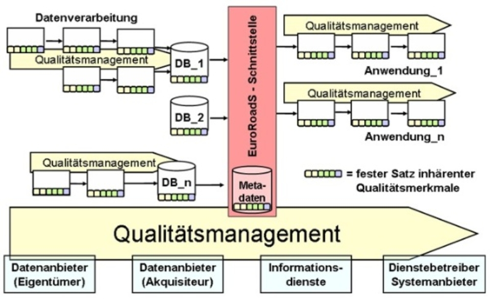
Special focus was put on the provision of existing road data from national or regional road authorities across Europe to application- or service providers. Therefore, EuroRoadS considered the complete information chain starting from the data acquisition up to the individual services.
The IIGS main field of activities in EuroRoadS was the development of a data quality concept as well as the development of quality assurance measures. The project verification of the quality management concept as well as the practical application of the quality assurance measures was done with the help of both, meta- and user data in the project’s field test sites.
Results:
The IIGS results are the specifications of a quality concept and a methodology for description and assessment / benchmarking of data quality within information processes.
Publications:
- Wiltschko, T., Kaufmann, T., Landwehr, M., Haspel, U. (2006): Speed limit acquisition and maintenance for administrative and safety related purposes. Experiences from the EuroRoadS-test site Bavaria. - In: Proceedings on 13th World Congress and Exhibition on Intelligent Transport Systems and Services. London.
- Wiltschko, T., Kaufmann, T., Landwehr, M. (2006): A way to quality assured road data for a speed alert system. - In: Proceedings on 3rd International Symposium “Networks for Mobility 2006”. Stuttgart.
- Kaufmann, T., Wiltschko, T. (2006): Zum Einsatz von Metadaten im Qualitätsmanagement - ein Metadatenkatalog für Straßendaten. – In: Strobl, J. et al (Hrsg.): Angewandte Geoinformatik. Beiträge zum 18.AGIT-Symposium 2006, Wichmann Verlag, Heidelberg, 2006.
- Kaufmann, T., Wiltschko, T. (2006): Quality assured road data by using the PDCA-cycle - experiences from EuroRoadS. – In: Proceedings on Transport Research Arena Europe 2006. Göteborg
- Möhlenbrink, W., Wiltschko, T., Kaufmann, T. (2006): Zur Nutzung von Geodaten in Telematiksystemen. – In: 9.Österreichischer Geodätentag 2006. Krems.
- Wiltschko, T., Kaufmann, T. (2005): Quality assured road information for ITS-applications – the quality concept of EuroRoadS. Proceedings on 12th World Congress and Exhibition on Intelligent Transport Systems and Services. San Francisco.
- Wiltschko, T., Kaufmann, T. (2005): A quality model for quality assurance of road information. - In: 5th European Congress and Exhibitionon intelligent transport systems and services ITS 2005.
- Wiltschko, T., Kaufmann, T. (2005): Modellierung und Bewertung der Qualität in Prozessen der Geodatenverarbeitung am Beispiel von Straßendaten. - In: Strobl, J. et al (Hrsg.): Angewandte Geoinformatik. XVII Beiträge zum AGIT-Symposium 2005, Wichmann Verlag, Heidelberg.
Kontakt

Martin Metzner
Dr.-Ing.Deputy Director / Head of Section Geo-Mobility and BIM