Integriertes hydrographisches Ortungssystem
Nowadays, highly precise positioning of surveying vessels on German inland waterways is mostly realized by Global Navigation Satellite Systems (GNSS) in Real Time Kinematic Mode (RTK). One important vulnerability of this method is that its reliability and its availability is depending to the measurement environment. Shadowing, multi-path effects, ionospheric influences and others decrease the accuracy of the computed position or even impede the determination of any solution. For this reason, an integrated hydrographic positioning system is developed.
Aim:
This project focuses on the development of methods to describe the spatial movement of surveying vessels without gaps and assure its quality by a dynamic model. Even if the GNSS signals are shadowed for durations up to 60 s, the deviation between predicted and the real position has to be smaller than 3 dm in the horizontal components and smaller than 1 dm in the vertical component. This is realized by integrating additional measurements from multiple sensors into the model.

Procedure:
An extendible multi-sensor system is configured to determine the position and the spatial orientation of the surveying vessel. Next to the core sensors (GNSS receivers, inertial measurement unit (IMU) and compass), the suitability of different sensors for this problem is investigated. Hence, a barometer, a Doppler Velocity Log (DVL), a camera, detecting units for inputs of the steerage and others are considered and installed. Processing of GNSS signals requires the reception of CORS data (SAPOS), so a RTK-solution is computed.
Also the integration of water levels provided by hydrodynamic models is investigated.
The actual state of the system “ship” is determined by an Extended Kalman Filter (EKF). Depending to the chosen sensor configuration, appropriate system and observation models are defined.
The evaluation process includes an outlier test to prevent that the estimated state of the system is influenced by appearing outliers. So, detected incompatibilities of the predicted system state and the corresponding observations can be eliminated. Besides, the plausibility of measurements, which are derived from GNSS observations, can be monitored by taking additional features into account (e. g. DOP values).
Changing external influences impact the movement behavior of the system “ship” during its journey on the water. Therefore the stochastic model can be adapted to the current situation by adaptive variance component estimation.
Result:
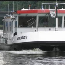
The HydrOs system is an executable prototype which is installed on the surveying vessel “Mercator”. In a minimal configuration, its hardware part contains a GNSS receiver (with connection to a CORS service), an IMU and a compass. It is highly recommended to combine the minimal configuration with a water level model, detecting units for inputs of the steerage and propulsion and data of the current flow velocity. The measurements of each particular sensor are acquired, recorded and processed by the software module of the HydrOs system. Evaluations can be performed in real-time mode but also in post processing mode. The processed results are used to georeference the data acquired by echo sounders. Hence, a three-dimensional model of the channel bottom can be realized.
In cases of interrupted GNSS signal reception, the accuracy requirements (1 dm in the vertical and 3 dm in the vertical components) can be reached with a confidence interval of 95 %.
Publications:
Publikationen:
Artz, T., Scheider, A., Breitenfeld, M., Brüggemann, T., Schwieger, V., Wirth, H. (2016): Improved positioning of surveying vessels on inland waterways with HydrOs.
Hydrographische Nachrichten (HN 105), 11/2016, S. 34 - 38; und HYDRO 2016, Rostock-Warnemünde, 08.-10.11.2016
Scheider, A.; Hassan, A.; Schwieger, V.; Breitenfeld, M.; Brüggemann, T.: (2016): Erweiterte Echtzeit- und Postprocessing-Verfahren zur Optimierung der GNSS-Ortung in Abschattungsbereichen an BWaStr. (Projektabschlussbericht HydrOs II) BfG-Bericht BfG-1892
Breitenfeld, M.; Wirth, H.; Brüggemann, T.; Scheider, A.; Schwieger, V. (2015): Entwicklung von Echtzeit- und Postprocessingverfahren zur Verbesserung der bisherigen Ortung mit Global Navigation Satellite Systems (GNSS) durch Kombination mit weiteren Sensoren sowie hydrologischen Daten. (Projektabschlussbericht HydrOs) BfG-Bericht BfG-1856
Wirth, H., Breitenfeld, M., Scheider, A., Schwieger, V. (2015): HydrOs - Ein integriertes Ortungssystem kombiniert mit hydrologischen Daten. Hydrographische Nachtrichten, Heft 6, 2015.
Breitenfeld, M., Wirth, H., Scheider, A., Schwieger, V. (2014): Development of a Multi-Sensor System to optimize the Positioning of Hydrographic Surveying Vessels. In: Schattenberg, J., Minßen, T.-F.: Proceedings on 4th International Conference on Machine Control and Guidance. TU Braunschweig, Braunschweig, 2014; und Interexpo Geo-Siberia, Novosibirsk, Russia, 16.-18.04.2014
Scheider, A., Wirth, H., Breitenfeld, M., Schwieger, V. (2014): HydrOs – An Integrated Hydrographic Positioning System for Surveying Vessels. FIG International Congress, Kuala Lumpur, Malaysia, 16.-21.06.2014.
Scheider, A., Schwieger, V. (2014): Optimierung eines Multisensorsystems zur hydrografischen Positionsbestimmung. 17. Internationaler Ingenieurvermessungskurs, 14.-17.01.2014 in Zürich; Posterpräsentation
Scheider, A., Schwieger, V. (2015): Entwicklung von Verfahren zur Verbesserung der Ortung mit Global Navigation Satellite Systems (GNSS). BfG Kolloquium: Neue Entwicklungen in der Gewässervermessung, Koblenz, 20./21.11.2012
Contact:

Volker Schwieger
Prof. Dr.-Ing. habil. Dr. h.c.Director of the Institute